SPONSORS
BECOME A
SPONSOR
We have 4 different
levels of sponsorship
that are available.We
believe that this site
will generate traffic
leads for your business
and since we are just
starting we have some
great rate plans.
Contact Rocko’ for
further information.


SWDeserts / Desert Magazine SW / My DesertMagazine LLC All Rights Reserved © 1937-2022


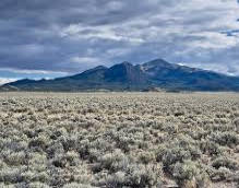
GREAT BASIN DESERT
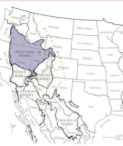


The Great Basin Desert is the largest US desert
and covers 190,000 square miles (490,000 km
2
). It is
bordered by the Sierra Nevada Range on the west and the Rocky Mountains on the east, the Columbia
Plateau to the north and the Mojave and Sonoran deserts to the south. The Great Basin Desert, unlike the
Mojave or Sonora deserts, characteristically "lacks creosote bush" as defined by J. Robert Macey in a 1986
report distinguishing between "Great Basin scrub desert" and "creosote bush desert."
[3]
Rainfall within the
Great Basin Desert region varies from seven to twelve inches per year. The Great Basin Desert includes
several arid basins lacking Larrea tridentata (chaparral) such as the "Chalfant, Hammil, Benton, and Queen
valleys," as well as all but the southeast portion of the Owens Valley. Conversely, the "Panamint, Saline, and
Eureka valleys" have creosote bush, unlike the Deep Springs Valley which includes part of the Great Basin
scrub desert.
The Great Basin Desert is a cold desert caused by the rain shadow effect from the Sierra Nevada to the
west.
The predominant flora are "continuous shadscale and…sagebrush."
The ecotone demarcating the north of the Mojave Desert is the edge of creosote bush habitat and is also
the south demarcation of the Great Basin shrub steppe and Central Basin and Range ecoregions.
[3]
The
ecotone is established by elevation increase, temperature decrease at higher elevations, and rainfall (less
rain shadow at higher latitudes).
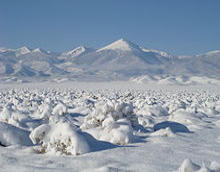
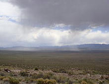
Climate
Climate varies throughout the Great Basin by elevation, latitude, and other factors. Higher elevations tend to
be cooler and receive more precipitation. The western areas of the basin tend to be drier than the eastern
areas because of the rain shadow of the Sierra Nevada. Most of the basin experiences a semi-arid or arid
climate with warm summers and cold winters. However, some of the mountainous areas in the basin are
high enough in elevation to experience an Alpine climate. Due to the region's altitude and aridity, most areas
in the Great Basin experience a substantial Diurnal temperature variation.
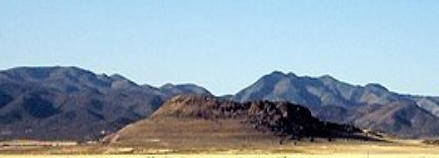
The Great Basin National Park, located in a central part of the Great Basin, provides perhaps the best
example of a typical climate for the region.
History
Sediment build-up over thousands of years filled the down-faulted basins between ranges and created
relatively flat lacustrine plains from Pleistocene lake beds of the Great Basin. For example, after forming
about 32,000 years ago, Lake Bonneville overflowed about 14,500 years ago in the Bonneville Flood
through Red Rock Pass and lowered to the "Provo Lake" level (the Great Salt Lake, Utah Lake, Sevier
Lake, Rush Lake, and Little Salt Lake remain).
Lake Lahontan, Lake Manly, and Lake Mojave were similar
Pleistocene lakes.
Paleo-Indian habitation by the Great Basin tribes began as early as 10,000 B.C. (the Numic-speaking
Shoshonean peoples arrived as late as 1000 A.D.). Archaeological evidence of habitation sites along the
shore of Lake Lahontan date from the end of the ice age when its shoreline was approximately 500 feet
(150 m) higher along the sides of the surrounding mountains. The Great Basin was inhabited for at least
several thousand years by Uto-Aztecan language group-speaking Native American Great Basin tribes,
including the Shoshone, Ute, Mono, and Northern Paiute.
Exploration of the Great Basin occurred during the 18th century Spanish colonization of the Americas. The
first American to cross the Great Basin from the Sierra Nevada was Jedediah Strong Smith in 1827. Peter
Skene Ogden of the British Hudson's Bay Company explored the Great Salt Lake and Humboldt River
regions in the late 1820s, following the eastern side of the Sierra Nevada to the Gulf of California. Benjamin
Bonneville explored the northeast portion during an 1832 expedition. The United States had acquired
control of the area north of the 42nd parallel via the 1819 Adams–Onís Treaty with Spain and 1846 Oregon
Treaty with Britain. The US gained control of most of the rest of the Great Basin via the 1848 Mexican
Cession. The first non-indigenous settlements
were connected with the eastern regions of the 1848
California Gold Rush, with its immigrants crossing the Great Basin on the California Trail along Nevada's
Humboldt River to Carson Pass in the Sierras. The first American religious settlement effort was the
Mormon provisional State of Deseret in 1849 in present day Utah and northern Nevada. They started
settling the Great Salt Lake Valley in 1847. The Oregon Territory was established in 1848 and the Utah
Territory in 1850.
In 1869 the First Transcontinental Railroad was completed at Promontory Summit in the Great Basin.
Around 1902, the San Pedro, Los Angeles and Salt Lake Railroad was constructed in the lower basin and
Mojave Desert for California-Nevada rail service to Las Vegas, Nevada.
To close a 1951 Indian Claims Commission case, the Western Shoshone Claims Distribution Act of 2004
established the United States payment of $117 million to the Great Basin tribe for the acquisition of 39,000
square miles (100,000 km
2
). The Dixie Valley, Nevada, earthquake (6.6-7.1) in the Great Basin was in 1954.
The Mojave and Colorado Deserts Biosphere Reserve (4 conserved areas) was designated in 1984, and in
1986, and 1994, the Great Basin National Park and the Mojave National Preserve were established. In
2009, the American Land Conservancy's Great Basin Program reserved the Green Gulch mule deer
migration corridor as part of "over 80,000 acres [conserved] in Nevada and the Eastern Sierras".
Settlements and Roads
The Great Basin's two most populous metropolitan areas are Reno to the west and Salt Lake City to the
east. The area between these two cities is sparsely populated, but includes the smaller cities of Delta, Elko,
Ely, Tonopah, Wendover, West Wendover, and Winnemucca.The Central Basin and Range has a mosaic of
xeric basins. The southern area of the basin has the communities of Palmdale, Victorville, and Palm
Springs. Major roadways traversing the Great Basin include Interstate 80, Interstate 15, U.S. Route 6, U.S.
Route 50, U.S. Route 93, U.S. Route 95 and U.S. Route 395, with the Nevada section of U.S. Route 50
nicknamed "The Loneliest Road in America."
[
The Great Basin is traversed by several rail lines including the
Union Pacific Railroad's Overland Route (Union Pacific Railroad) through Reno and Ogden, Feather River
Route, Central Corridor and Los Angeles and Salt Lake Railroad. The Great Basin was once predominately
inhabited by the Great Basin tribes.
Ecology
Although mostly within the North American Desert ecoregion, portions of the Great Basin extend into the
Forested Mountain and Mediterranean California ecoregions. The semi-arid areas of the Forested
Mountain ecoregion include the White Mountains and Inyo Mountains.
Extending north of the 42nd
parallel north, the Northern Basin and Range (ecoregion) has its southern border at the highest
shoreline of the Pleistocene Lake Bonneville. The south edge of the Central Basin and Range ecoregion
is in Nevada, north of the south edge of the Great Basin section.
In phytogeography, the Great Basin is within the Great Basin (floristic) Province of the Madrean Region
in southwestern North America. The floristic province and region are within the Holarctic Kingdom, of the
northern Western Hemisphere..
Fauna
Great Basin wildlife includes pronghorn, mule deer, mountain lion, and lagomorphs such as black-tailed
jackrabbit and desert cottontail and the coyotes that prey on them. Packrats, kangaroo rats and other
small rodents are also common, but these are predominantly nocturnal. Elk and bighorn sheep are
present but uncommon. Small lizards such as the Great Basin fence lizard, longnose leopard lizard and
horned lizard are common, especially in lower elevations. Rattlesnakes and gopher snakes are also
present. The Inyo Mountains salamander is endangered. Shorebirds such as phalaropes and curlews
can be found in wet areas. American white pelicans are common at Pyramid Lake. Golden eagles are
also very common in the Great Basin. Mourning dove, western meadowlark, black-billed magpie, and
common raven are other common bird species.
Two endangered species of fish are found in Pyramid Lake: the Cui-ui sucker fish (endangered 1967)
and the Lahontan cutthroat trout (threatened 1970).
Large invertebrates include tarantulas (Aphonopelma genus) and Mormon crickets. Exotic species,
including chukar, grey partridge, and Himalayan snowcock, have been successfully introduced to the
Great Basin, although the latter has only thrived in the Ruby Mountains. Cheatgrass, an invasive
species which was unintentionally introduced, forms a critical portion of their diets. Feral horses
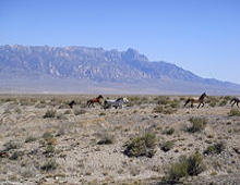
(mustangs) and wild burros are other highly reproductive, and ecosystem-controversial, alien species.
Most of the Great Basin is open range and domestic cattle and sheep are widespread.
Flora
Utah juniper/single-leaf pinyon (southern regions) and mountain mahogany (northern regions) form
open pinyon-juniper woodland on the slopes of most ranges. Stands of limber pine and Great Basin
bristlecone pine (Pinus longaeva) can be found in some of the higher ranges (the Methuselah tree is
nearly 5000 years old). In riparian areas with dependable water cottonwoods (Populus fremontii) and
quaking aspen (Populus tremuloides) groves exist. Grasslands contain the native Great Basin wildrye.
Hydrology
The Great Basin Divide separates the Great Basin from the watersheds draining to the Pacific Ocean.
The southernmost portion of the Great Basin is the watershed area of the Laguna Salada. The Great
Basin's longest and largest river is the Bear River of 350 mi (560 km), and the largest single watershed
is the Humboldt River drainage of roughly 17,000 sq mi (44,000 km
2
). Most Great Basin precipitation is
snow, and the precipitation that neither evaporates nor is extracted for human use will sink into
groundwater aquifers, while evaporation of collected water occurs from geographic sinks.
Lake Tahoe,
North America's largest alpine lake, is part of the Great Basin's central Lahontan subregion. Great Basin
named deserts include the Black Rock Desert, the Great Salt Lake Desert, the Sevier Desert, the
Smoke Creek Desert, Nevada salt deserts in the Great Basin Province, the Mojave Desert, and part of
the Sonoran Desert.
Text is available under the Creative Commons Attribution-ShareAlike License; additional terms may apply.Wikipedia® is a registered trademark
of the Wikimedia Foundation, Inc., a non-profit organization.
Desert Adventures & Exploring....Since 1937

OF THE SOUTHWEST